Saturday 27 April 2013

Volcanoes and Bananas

We are awaiting wind. This is typical of the Canaries. They fluctuate from far too much wind to not enough, with the occasional shock of an unexpected acceleration zone where winds can reach 30 - 40 knots quickly.

We took  a bus to Fuencaliente in the South of the island, the area of volcanic activity.  You can imagine Tristan's pleas ....'no more volcano's'.

The walk was from the volcano San Antonio visitors centre down to Faro de Fuencaliente and the salt  pans a distance of around  7km's but my calves disagree.

We decided not to pay to see a volcanic crater which last erupted in 1677,  but opted to walk downhill to the coast. In the middle of nowhere you came across grape vines growing in the cinders.

This area of La Palma is famous for its wines grown on the island since 1505, which accounted for  the number of bodega's we passed en route.

Malmsey wine was praised by Shakespeare and his contemporaries. I have yet to try it!


Vineyards on the slopes around Volcano San Antonio with the marina in the very far distance.

Random vineyard in front of Volcano Teneguia


It was blazing hot and with all the black cinders the temperatures soared. We resorted to drinking out of the water canals using Tristan's hat.....may regret this later!


The San Antonio cinder cone.


The  San Antonio cinder cone was impressive  but as we walked down  towards the Volcano Teneguia (439m) which last erupted in 1971,  the destructive force was even more impressive.


 I remember the images on the television. It took a bit of nerve for me to walk up to the edge of the crater as the path was strewn with cinder, and  surrounded by sheer drops either side of the path. Being called a wuss helped!


You knew you would be in trouble if you slipped. The view at
the top was spectacular (if you like volcanoes he muttered!).


I should have realised from walking down Etna, that sandals were a bad idea, but the volcanic material on El Hierro was completely different and much easier to walk on so I had long abandoned my boots.   At least it gave me an excuse to stop (every five minutes)  and empty my sandals! The lava was quite different from El Hierro, mainly sharp cinders (scoria)  ranging in colour from reds to blacks and bluish tinges where the material had come into contact with water when it erupted.


The salt pans  were adjacent to the two lighthouses. Faro Negra was damaged during the volcanic eruption of 1971 and they built a new red and white striped one adjacent. There is absolutely nothing here but the lighthouses and the salt pans.


They were rebuilding the visitors centre so we walked around the salt pans following the information boards.
By this time we were desperate for water ....and filled up the bottles from a tap. The green floaty bits were a bit off putting but was no where else to get water.

The  process of salt recovery was interesting......

Water is pumped to inlet pools which trickle the water down into the saltpans. The colour is due to an algae Dunaliella salina and aparently there are also brine shrimps, Artemia which I remember my girls having as pets when the were young. Sea monkeys! These should have been a trade description issue!


Fortunately a gua gua returned us to Fuencaliente but via the most extensive plantations of bananas yet. Considering the number of bananas on this island, I reckon they must supply most of Europe.

You used to be able to buy banana puree to drink on the islands but it seems to have disappeared. However there is an increase in the number of cosmetics using bananas which I'm sure is much more profitable!

Wednesday 24 April 2013

Work Shy

We know we have jobs to do but  need head space to work through the problems.


We have  mended the blown out mainsail and fitted a new electric bilge pump,  then gave ourselves a few days off as our hands hurt, and to source the pipe for re-routing the manual bilge pumps .


The marina is at Tarajal, along the coast from Puerto Tazacorte.  The most spectacular thing about this place is the beach and the barranco.


This deep valley of the Taburiente/Augustias River  breaches the crater walls of the  Caldera de Taburiente., and runs out to sea at the old port of Tazacorte. The Caldera is the largest volcanic crater in the world. We have yet to walk up to it.......still fixing bilge pumps!

Los Llanos  is characterful with its plaza's  and shops.


These palm trees were planted in 1929 so they are younger than my Mum!


We have been shop less for two months so its been great to be able to find what we need in the Ferretaria's and Chandler's, but its still not great especially if we need to carry out work on the boat.

The whole of this part of the island is surrounded by banana plantations......apparently there is a high incidence of asthma due to the pollen. We thought we would build up our immunity by eating the local honey but it tastes like burnt sugar and not a patch on El Hierro's honey!


There is a really pretty walk through the banana plantations from Tazacorte to the marina......part of it follows the sewage pipeline (which I've been told not to mention), and there are rather a lot of spiders!


The bus service around the island is fantastic.....off we went to Santa Cruz.We crossed from the west to the east of the island via a very long tunnel.  Santa Cruz is  typically Spanish, buildings around a central courtyard, surrounded by wooden balconies....beautiful.


We are glad we are in Tazacorte as the boats in the marina were rocking.....I'd need stugeron to be in the harbour.


Back in Tazacorte........

  If I lived there I would be worried!
Whatever the activity.......you can't have balls! Look closely....


In the mean time we have taken all of the floors out of the boat and we are gradually sorting everything out. Its a bit of work but I have a carpenter, and as Ron use to say, 'There's no point having a dog and barking yourself'!


Wednesday 17 April 2013

All boats are sinking........

After several,'when are you leaving?', 'Manana'. We eventually left. Its always hard to leave a place you have enjoyed , and El Hierro was a very special place.  We decided to leave at 4 am with the aim of arriving in our next destination, Tazacorte,  La Palma, before nightfall.

It was quite an experience following the coast in nautical twilight and being able to orientate yourself to places you had walked in the previous weeks.

The smell of the pine forest was evocative of the taste of El Hierro's honey and we had a stash of yoghurt's  and quesadilla's for our journey.


The sun rose as we approached the  Meridian and Orchilla Lighthouse. We had been on the Sea of Calmas  and as soon as we rounded the southwest tip of the island, we picked up a North East wind.

This was the area where the recent swarm of earthquakes had hit El Hierro .....and we sailed right over the spot , tacking towards  El Golfo.

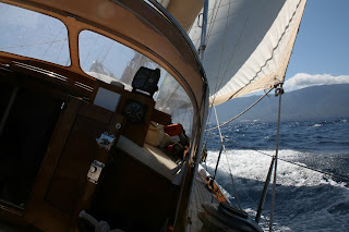
       The wind was flukey and one minute we had the gunnels underwater making 7 knots upwind reefed down, the next we drifted and had to resort to using the engine.

This certainly gave Meriva her 'trial' sail after all the recaulking but Tristan was torn between adjusting the sails and pumping the bilge.


We were unable to buy a replacement electric pump on El Hierro so we always new this might  be a strenuous trip.


We were joined by a pod of dolphins.
I clung to the genoa as we bounced into the rising seas....in the end gave up photographing the dolphins as the motion of the ocean was 'challenging'.  I had to concentrate on sailing otherwise I was threatened with a swimming lesson.


The seas were very 'confused'  but Meriva was brilliant at sailing upwind.  Our concern was there was still water coming in,not from the repairs but from around the mast-step where we were unsure whether work was needed. Turns out it is needed! It  did not put us in danger and was not unmanageable but we felt we needed to address the problem once we arrived at our next destination.

It took us longer than we had anticipated  and after 22 hours at sea without a break we were both exhausted. Its amazing how your eyes play tricks on you when you are entering a port at night. Tristan was calling the sailing directions to me, but on the horizon it looked like the other way was the right way. These 'false friends' would have spelt disaster.....the next morning the hotels and artistic structures did not exist, in fact they were cliffs, submerged rocks and banana plantations!

We finally tied up to the reception pontoon at 2 am and  I took a brandy as my comfort, Tristan a large bar of Turon!  Sleep was the easy bit. Waking up the next morning to put the boat onto a pontoon berth was difficult, although we had plenty of choice as the berths were empty.  We had a lot of mopping up to do......the hatch had leaked again, and the hanging locker was not totally dry.  Its not such a problem......out with the washing lines and buckets. I've quite a routine going on now, and as Tristan says, 'All boats are sinking, its just a question of how quickly'.

Monday 1 April 2013

The Great White Hunter

We decided our reward for all the hard work on Meriva's hull,  was to hire a jeep and tour El Hierro. Although the buses and gua guas are brilliant for linking up, its easier not to be tied by time.


El Hierro is the smallest  of the Canary Islands with an area of 27km squared and is the most recent in its geological formation. The triangular shape is due to three rifts which form its spine, and over the years giant
landslides have created El Golfo, El Juan and Las Playas.


We decided to start our tour at the Valley of Las Playas viewpoint. After driving down an unmade road into the pine forest, we found we had the best internet connection to date.....in the middle of no where! The crescent shaped collapse is 5km in diameter and 1000metres high.

The views down to the Parador at Las Playas were spectacular....bit unnerving when we heard a loud bang followed by  the sound of falling rock.
Its hard to conceive the volume of material that has fallen into the sea creating this area.


The diversity of flora on the island is fantastic. Just in the small area around the view point.


Unfortunately I only bought one floral guide with me so latin names will be added at a later date!


The countryside is spectacular with meadows and a profusion of colour, dotted with the occasional hobbled cow. Hobbled because the walls here are so low.


We drove to El Garoe, the Sacred Tree  above a well which was the 'source ' of water for the island.


Water picked up by the trade winds condenses on the mountains and trees, known as horizontal rain, it collects in natural pools. The original tree was blown down in a hurricane in 1610.

The water from this Garoe tree was used by ancient islanders, the Bimbaches, until the 15th century. The current Laurel Tree was planted in the last century actually in the main pool, not above it. The pool had been filled with earth after it lost its clay lining.

We took a deserted road to Jinama but the view was obscured by low cloud.

Tristan had previously walked  from Sabinosa on the south west of the island to El Pinar on the east with Francoise, a fellow traveller and was keen to go back to see the area without knee hieght cloud.


View over El Golfo, the second of the rifts that has collapsed into the sea. Landslides have been happening in this area during the recent seismic activity.


We lunched at Frontera, one of the most seismically active parts of the island,  followed by the drive of our lives. The road from Frontera to Sabinosa and down towards the sea is 'scary' but that was nothing compared to the butt clenching road from Sabinosa along the coast to the Monumento Meridiano! Its a good job we did it when we did as this road is now closed due to the hundreds of earthquakes in the area over the last few days, the largest being 4.9 on the Richter scale. Sabinosa has  changed its GPS position by 2cm  during this last burst of seismic activity and the island has been raised by 11cm.

 View from the parador at Sabinosa towards the area of El Hierro that is currently most volcanically active. Most of the earthquakes are out to sea.


 The scree slopes are very unstable at the moment as magma is being pushed under the island triggering landslides

Monitoring seismic activity


The road disappears and its difficult to see where you are going.....no safety barriers here!


Mirador de  Lomo Negra II at 260 m . Some of the rocks have a bluish tinge due to sea water coming in contact with very hot lava......very pretty.


We followed the road around the coast towards El Juan, the third collapsed rift.

View over El Juan.
The choice was to visit the Orchilla Lighthouse or the Meridian Monument. We opted for the latter. The road disappeared and went into a  cinder track. The tracks osteopaths love!

The Meridian monument marked the spot where one of the many meridians existed before being moved to Greenwich.


From here we meandered back to La Restinga through the pine forests.


Weird things turn up here  like giant floating orange squash bottles!


Our time in La Restinga is nearlly over. It has been an unforgetable experience. We have been covered in Saraha Dust during a Calima, experienced my first earthquake and survived hurricane force winds whilst being propped up in trees,acroprops and oil drums.
We have savored the delights of  Pastor de Oveja and El Tomillar, Quesadilla, and fresh fish  from the local Pescadores Cooperative.


We have met some wonderful people who have a fantastic lifestyle on a 'tranquil' island.